-8883-p.jpg?v=7db4a17b-5b1a-4a86-a63f-5b78fb8a8592)
-8883-p.jpg?v=7db4a17b-5b1a-4a86-a63f-5b78fb8a8592)
-8883-p.jpg?v=B800C3DD-A0F5-463E-8EF8-F00896D5BCDA)
-8883-p.jpg?v=09565B85-6095-4E1F-8A6F-E88B2AE03AED)

-8883-p.jpg?v=09565B85-6095-4E1F-8A6F-E88B2AE03AED)


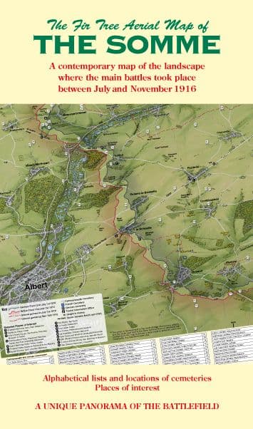
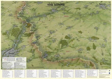
A unique Aerial Map of The Somme Battlefield clearly showing the ridges, valleys and woods that played such a significant part in the outcome of The Somme Offensive in 1916.
The Clear and detailed cartography allows the user to gain an instant appreciation of the landscape where the battles were fought.
Over 90 Cemeteries are listed in alphabetical order in an information panel on the map and are easy to locate on the map. British and German front lines, principal memorials and sites of interest.
If you are visiting the area or conducting some armchair research this map will aid you immensely.
A2 size 594 x 420mm. Available flat, laminated or folded. This is the FLAT & ROLLED version
These Fir Tree Aerial Maps of the Somme and the Ypres Salient are so good that, in case I lose one, I have already bought two copies of each! I have many guides for Western Front field trips, which I have been doing for years, but none is as accessible as these. For both the novice and the slightly more experienced visitor, they make 'finding your way around' so much easier, not just literally but also when reading up on the key engagements of the First World War. I recommend that you get both into your rucksack without delay!
Richard Hendry
Please Note: £1.00 will be donated to The Lochnagar Crater Foundation for each of these maps bought through this website.
I have been studying and visiting the Western Front for 32 years, have been a tour guide for 8 years and WW1 Battlefields Alive has a consistent 5-star rating on TripAdvisor. In all that time I have come across many maps - most of them useless. What a revelation! The Fir Tree Aerial Map of The Somme is without doubt the most useful map that anyone has ever produced of the Somme area.
Bob Findley
ww1battlefieldsalive.com
An Excellent and novel method of providing an overview of The 1916 Somme Battlefield.
Martin Middlebrook, author of The First Day on The Somme.
For artist Richard Chandler to produce the map, work started in 2013 and involved extensive research on the ground walking and cycling the roads, paths and fields around the battle area to gain an intimate knowledge and photographs of the terrain.
This continued at his Fir Tree Cottage Studio to convert the information gathered into a three dimensional and accurate hand painted image. The finished map took in excess of 1,000 hours to produce. As with all of his work the finished print represents a 'Labour of Love' for Richard who has found this map to be one of his greatest challenges.
Richard is immensely proud of this Aerial Map of The Somme and hopes that it will be a useful resource for all those who wish to study what was one of the most important battles in British Military History.
Customer reviews
| Isbn Number | 9780956732965 |
| Brand | Fir Tree Maps |
| Condition | New |
| Weight | 0.8kg |
You may also like
-
Aerial Map of Fir Tree The Somme Battlefield 1916 - Folded
£9.95The Somme Battlefield 1916 - Folded A Contemporary map of the landscape where the battles took place between July and November 1916 -
Aerial Map of The Somme Battlefield 1916 - Flat, Rolled and Laminated
£14.95The Somme Battlefield 1916 - Flat/rolled and Laminated A Contemporary map of the landscape where the battles took place between July and November 1916