-8871-p.jpg?v=1732021-114331)
-8871-p.jpg?v=1732021-114331)
-8871-p.jpg?v=1732021-114331)


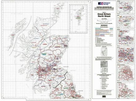
GB Parliamentary Constituency Map
Map size: A0 (1189 x 841mm approx)
Your Map will be centred on an individual Constituency and will use the appropriate mapping for the size of the constituency.
Please note this map will also include parts of adjacent constituencies as shown in the images
Within each Constituency the map will show the Ward/Division boundaries.
As each Constituency is of a different geographical size each map is produced individually just for you and we will use the appropriate mapping style, therefore the map style may vary from the one shown. If you would like to see a preview of your map please simply ask.
If you would like to call and speak to a human or order a preview before you order please call Jonathan on 01432 266322 or email enquiries@themapcentre.com
We cover England, Scotland & Wales (sorry not Northern Ireland)
Finish options
140gsm Premium Print Paper
Encapsulated Map - 125micron write-on/wipe-off Plastic Laminate
Customer reviews
| Condition | New |
| Weight | 2kg |
You may also like
-
OS Administrative Boundary Map Electoral Boundaries - Sheet 1a - Northern Great Britain
From: £25.00OS Administrative Boundary Map Electoral Boundaries - Sheet 1a - Northern Great Britain -

OS Administrative Boundary Map Electoral Boundaries - Sheet 1b - Southern Great Britain
From: £25.00OS Administrative Boundary Map Electoral Boundaries - Sheet 1b - Southern Great Britain